|
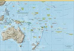
| Click on the map to see it in greater detail. (Map courtesy of the Central Intelligence Agency World Factbook 2004.) |
Background:
Draw a line from Hawai'i southeast to Pitcairn Island, made famous by the mutineers of The Bounty; draw a second line southwest from Pitcairn to New Zealand; draw a third line from New Zealand northwest to the Philippines, avoiding Australia as you go; and finally draw a fourth line from the Philippines back to Hawai'i. This rather sloppy rectangle encloses the thousands of islands known loosely as the Pacific Islands. More specifically it marks off three geographic regions: Polynesia (the sweeping southeastern side of the rectangle), Melanesia (including New Guinea and islands to the east), and Micronesia (islands to the north and east of New Guinea).
Anthropologists have known for some time that the first human inhabitants of many of these islands had arrived by at least 1500 BC, apparently originating from New Guinea and its surrounding islands. But this raises an interesting question. Given that the magnetic compass would not be invented for at least another 2000 years, how did the early people of this region manage to make their way from one island to another without getting lost?
Swayed perhaps by the fact that European voyagers had from the beginning been dependent upon the compass, researchers used to believe that these early island journeys were basically accidents. The Pacific voyagers set sail into the unknown, and if they were lucky stumbled across an island and settled there. However, more recent discoveries have made it clear that these trips were anything but accidental, that these early people possessed remarkable navigational skills, and moreover that these ancient skills are still in use today.
Astronomical significance:
The techniques employed by modern ppalu—navigators trained in the traditional skills—have been shown to date back at least 4000 years. They make use of a complete understanding of the ocean's movements and appearances—its currents, swells, colors, winds, temperature variations, even its birds—to recognize the cardinal directions north, south, east and west; to pinpoint islands before they can be seen; and to generally keep track of one's place in the seemingly featureless, directionless expanse of the open seas. They also make use of a considerable knowledge of astronomy.
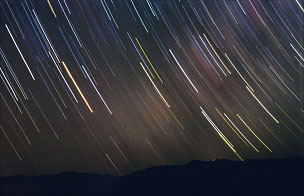 |
| As Earth rotates, the stars appear to move through the sky, rising and eventually setting at the same point on the horizon each night. (Photo by Carlos Milovic, courtesy of the European Southern Observatory.) |
Although the specific astronomical techniques used by ancient island mariners varied somewhat from place to place, there appears to have been a remarkable degree of similarity across the entire region. One common technique utilized the points along the horizon where particular stars rise and set. Because all day-to-day motion in the sky is due to the Earth's rotation, the stars appear to rise in the east, travel across the sky, and set in the west each night just as the Sun does each day. Unlike the Sun, however, the stars rise and set at exactly the same point on the horizon every day, year after year. (There is a small shift that builds up over hundreds and thousands of years due to Earth's precession, but this would not be noticeable in a navigator's own lifetime.) However, the time of night when a star rises or sets will change throughout the year due to Earth's orbit.
To see how this navigational method works, imagine that you are on your home island and you wish to sail in some direction—shall we say 32 deg. north of east?—to another island, your destination island. How do you do this? Well, first you consider the time of year and use your knowledge of the sky to tell you which star will be rising 32 deg. north of east when the Sun is just setting. Then, as the Sun sets and the stars begin to appear, you find your guide star on the horizon and steer your course accordingly.
Of course as the night wears on, Earth's rotation will slowly lift your guide star higher and higher in the sky, so that in an hour or two it will be too far above the horizon to be a useful guide. However, your knowledge of astronomy tells you that by that time, another star will be rising up from the same place on the horizon, following your first guide star. You therefore begin watching for this second star, and as soon as it appears, it becomes your new guide star. Then, by the time this second star has risen too high, a third guide star will be rising from the same place, and so on.
By following this chain of stars, all of which rise from the same point on the horizon—a chain of stars known as a kavenga (or kaveinga, depending on the local language)—you can stay on course throughout the night. Ancient navigators had to memorize a different kavenga for each of many distinct directions on the horizon, and of course they had to be able to recognize every star in each kavenga wherever it was in the sky, at whatever time of year.
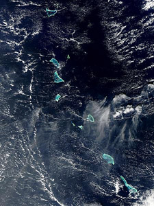 |
| The Kiribati Islands. (Photo courtesy of NASA's Visible Earth.) |
This idea of the kavenga, also known as a star path, is closely related to the star compass. A star compass uses a circle to represent the horizon, much like a modern compass does, but instead of being marked with only the cardinal directions, the star compass is marked with the names of stars that rise at various points. Although the particular stars that were used vary from place to place, some form of star compass appears to have been used by numerous cultures across the South Pacific.
Another navigational technique utilized what is known as an etak. An etak is an island that you use as a reference point on your journey. Let's say you are voyaging from your home island to some destination island. Your etak, or reference island, would lie somewhere between your home and your destination, but off to the side some distance. As a skilled navigator, you would already have chosen this etak island in advance. You would also know a series of stars that would appear successively above the etak as you proceed along your course. When the etak island appears to have moved from one star to the next, your boat will have moved a distance referred to as one "etak." This distance will vary somewhat throughout your journey, since the stars are not evenly spaced, but the etak island and the stars will have been chosen in such a way that one "etak" of distance is around 20 miles.
David Lewis, who deserves much of the credit for drawing the world's attention to the methods of Pacific Island navigators, mentions in his book The Voyaging Stars the following conversation that he had with Hipour, a modern day navigator:
Hipour collected together an assortment of miscellaneous objects, including a pocket knife, some fishhooks and a few coins.
"Here is your canoe." He pointed to the knife. "These fishhooks are three islands, the one you are leaving, the one you are bound for and, away out at right angles to your course, the etak or reference island. The coins are the star compass points.
"From your home island the etak island lies 'under' Antares. [I have substituted the Western star names.] By the time your canoe is here"—he shifted the knife to point B—"the etak island has 'moved' to the star point Aldebaran. When you reach your goal the etak island has 'moved' further back still. Now it is 'under' the Pleiades.
"All the while you will be judging in your mind how far back your etak island has moved. Each star point that it moves back means that you have progressed one etak."*
Using these and other clever yet straightforward methods, ocean voyagers of the South Pacific—both ancient and present day—have journeyed not only the hundreds of miles between neighboring islands, but even the thousands of miles that separate Hawai'i from the islands of southern Polynesia, Micronesia, and Melanesia. In this high–tech age, many people would find it incredible that anyone could navigate such distances with nothing but the stars and a knowledge of the sea. But quoting the modern day canoe captain Ve'etutu Pahulu, "I did have a compass once, but I gave it away. The star path—kaveinga—is more to be trusted than any compass."†
Citations:
* David Lewis, The Voyaging Stars: Secrets of the Pacific Island Navigators, Norton & Company, New York, 1978, p. 145.
† Ibid., p. 75.
References:
Lewis, David, The Voyaging Stars: Secrets of the Pacific Island Navigators, Norton & Company, New York, 1978.
Other useful links and references:
Kelley, David H., and Eugene F. Milone, Exploring Ancient Skies: An Encyclopedic Survey of Archaeoastronomy, Springer, New York, 2005.
Lewis, David, We, The Navigators: The Ancient Art of Landfinding in the
Pacific, University of Hawaii Press, Honolulu, 1975.